


MP Weather Alert March 2026: Thunderstorms Return on March 27–28 After Killer Heatwave — What Bhopal, Indore and 20 Districts Must Prepare For Right Now
Digital Desk
The Sky Cannot Make Up Its Mind — And That Is the Problem
If you live in Madhya Pradesh, the last ten days have been a meteorological whiplash. Brutal hailstorms one day. Scorching 38°C heat the next. And now, just as residents were beginning to settle into early summer routines, the India Meteorological Department has issued a fresh MP weather alert for March 27 and 28 — thunderstorms and rain are coming back.
This is not routine March weather. This is a pattern that forecasters are calling one of the most volatile weather months the state has seen in years — and the consequences are being felt in homes, farms and city streets across Madhya Pradesh.
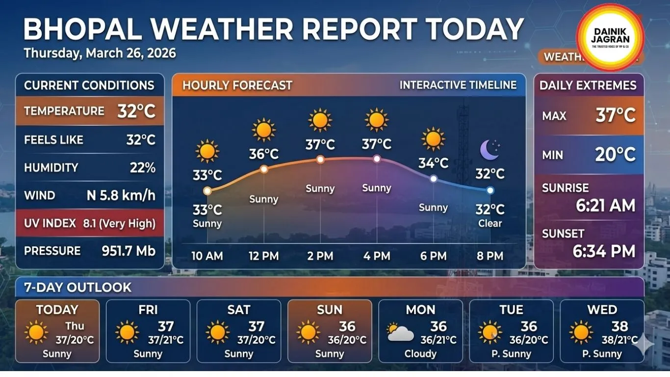
What Is Happening Right Now: March 26 Weather Update
Today, March 26, marks the activation of a new Western Disturbance over northwest India. Its effects are already beginning to ripple southward into Madhya Pradesh.
For most of the state, today is still a hot day. Bhopal is recording temperatures close to 38°C. Indore and Ujjain are not far behind. Eastern and western parts of the state are seeing some cloud cover, while central divisions continue to bake under strong afternoon sun.
But the calm is deceptive. Senior IMD weather scientist Dr. Divya E. Surendran has confirmed that the full impact of the Western Disturbance will be felt over the next two days — particularly in Gwalior, Chambal, Sagar and Rewa divisions. A second Western Disturbance may also become active around March 28, potentially extending the unsettled weather further.
IMD Alert: Which Districts Are at Risk on March 27–28
The IMD's Bhopal meteorological centre has issued thunderstorm and rain alerts covering more than 20 districts in the northern and eastern belts of the state. Districts in the Gwalior-Chambal division — including Gwalior, Morena, Bhind, Sheopur and Datia — are at highest risk of severe thunderstorms with gusty winds reaching 40 to 50 kilometres per hour.
The Sagar, Rewa and Shahdol divisions are also in the warning zone, with Jabalpur, Narsinghpur, Katni, Satna, Sidhi, Singrauli, Umaria and Panna all expecting storm activity by March 28.
For Bhopal, Indore, and Ujjain, the alert is for partial cloud cover and the possibility of isolated thunderstorms — not as severe as the northern districts, but residents should remain alert to sudden weather changes, especially during evening and night hours when storm activity typically peaks.
A Month of Weather Extremes: What March 2026 Has Already Delivered
To understand why this latest alert matters, you need to look at what March has already thrown at Madhya Pradesh.
Between March 18 and March 22, a powerful weather system driven by three simultaneous atmospheric troughs and a cyclonic circulation battered 45 of the state's 52 districts for nearly 98 continuous hours. More than 112 towns and cities recorded rainfall. Seventeen districts reported hailstorms. Crops of wheat, gram, banana and oranges were damaged across vast swathes of the state.
Then, almost overnight, the system cleared on March 22 — and temperatures immediately spiked. Narmadapuram hit 40.1°C. Bhopal crossed 37.8°C. Indore touched 37.6°C. Cities that had been receiving rain and hail just days earlier were suddenly sweltering in pre-summer heat.
This storm-then-heatwave-then-storm pattern is not a coincidence. February 2026 alone saw four separate rounds of hailstorms and unseasonal rain. March has continued and amplified that trend. Meteorologists say this instability is a direct consequence of multiple atmospheric systems colliding over central India at unusual frequency.
The Farmer's Crisis: Caught Between Storm and Heat
If city dwellers are frustrated by the weather swings, spare a thought for Madhya Pradesh's farming community. This is the most critical window of the agricultural calendar — the wheat and gram harvest season — and the timing of these repeated weather events could not be more damaging.
Hailstorms in the Gwalior-Chambal region reportedly damaged nearly 50 percent of standing crops in some areas. Farmers in Alirajpur, Barwani, Vidisha, Betul and Khandwa have reported significant losses to harvested and unharvested produce alike.
With another round of thunderstorms and rain now forecast for March 27–28, the IMD and agricultural authorities are urging farmers across all alert districts to complete harvesting immediately, move harvested grain to covered or elevated storage, and protect standing crops with available means before the next system arrives.
The Bigger Picture: A Brutal Summer Is Coming
The March MP weather alert is not just about the next 48 hours. It is a warning shot for what lies ahead.
IMD meteorologists have formally warned that April and May 2026 will be among the hottest months Madhya Pradesh has experienced in years. Temperatures are expected to cross 45°C in the Gwalior-Chambal, Jabalpur, Rewa, Shahdol and Sagar divisions. Bhopal, Indore, Ujjain and Narmadapuram are also expected to face severe, sustained heat.
Perhaps most strikingly, forecasters have warned that heatwave spells this summer could last 15 to 20 continuous days — compared to the one to two-day heatwave episodes that have been more typical for the region in recent years. That is not a subtle shift. That is a structural change in how summers will feel across central India.
What You Should Do Right Now: Safety Checklist
Whether you are in a district under active alert or simply living through the daily heat, here is what the IMD and safety authorities are advising:
For residents in thunderstorm alert districts (March 27–28):
- Stay indoors during evening hours — most storm activity peaks between 4 PM and 9 PM
- Avoid open fields, tall trees, electric poles and rooftops during lightning warnings
- Do not travel on flooded or waterlogged roads after heavy rain
- Keep emergency contacts and torch lights handy in case of power outages
For everyone dealing with the heat:
- Avoid direct sun exposure between 11 AM and 4 PM
- Stay well hydrated — keep water, ORS and cooling foods accessible
- Keep elderly residents and young children indoors during peak afternoon heat
- Watch for signs of heat exhaustion — dizziness, nausea, rapid heartbeat
For farmers in alert districts:
- Complete wheat and gram harvesting before the evening of March 26
- Move harvested produce to covered, elevated storage immediately
- Do not leave freshly cut crops exposed overnight in districts under rain alert
.jpg)


