MP Rain Alert: Biaora Records 229 mm as Low-Pressure System Revives Monsoon; Deficit Persists in East MP
Digital desk
Bhopal’s deficit has been erased, but West Madhya Pradesh remains 10% below normal and East Madhya Pradesh 18% deficient. More heavy rain is forecast this week
An intense monsoon spell has brought extremely heavy rainfall to parts of western Madhya Pradesh, flooding low-lying areas, raising reservoir levels and dramatically improving rainfall figures in Bhopal.
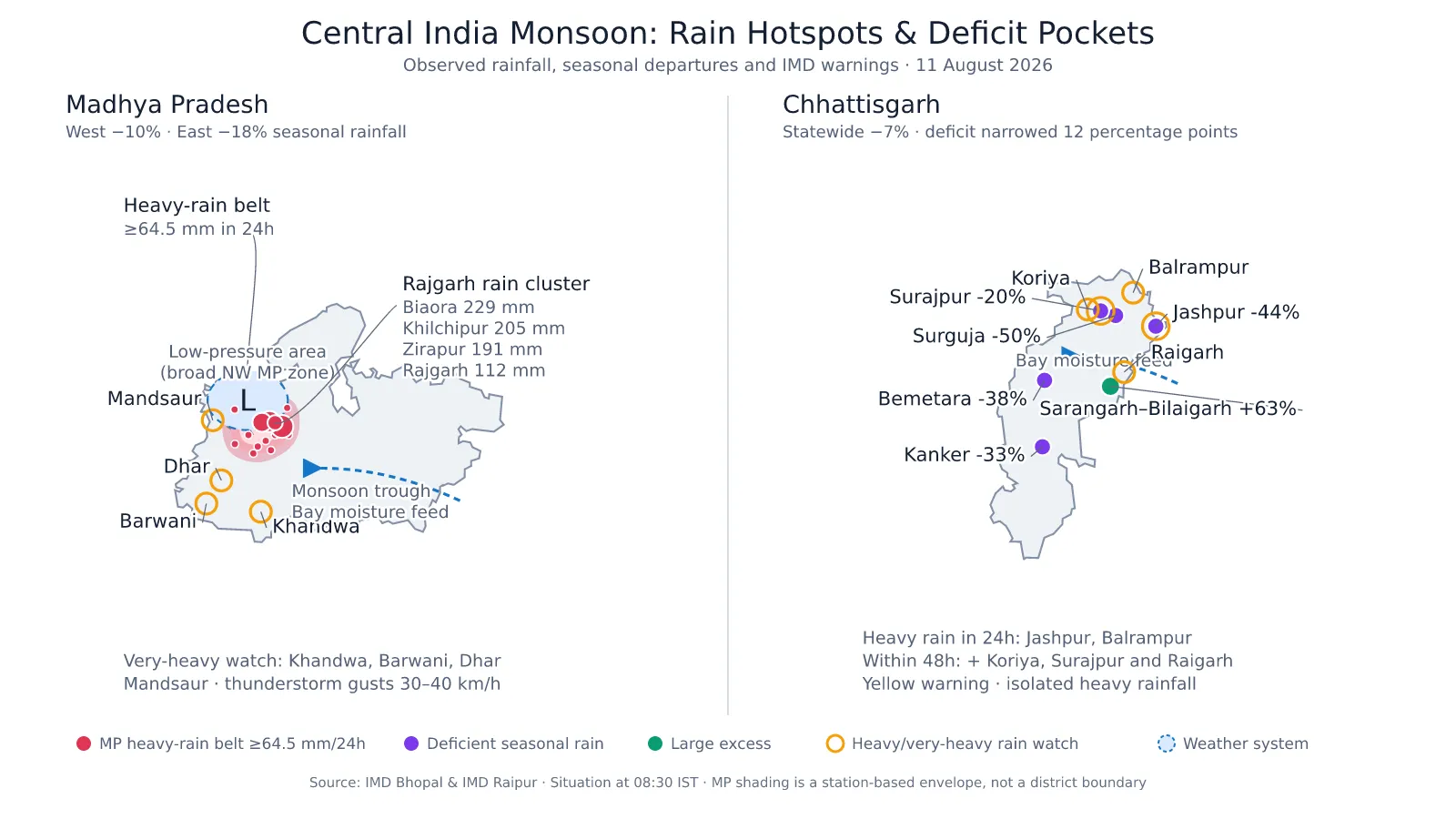
Biaora in Rajgarh district recorded 229 mm of rainfall during the 24 hours ending Tuesday morning, while Khilchipur received 205 mm and Zirapur 191 mm, according to the India Meteorological Department.
Rajgarh recorded 112 mm, Gulana 102 mm, Narsinghgarh 95 mm, Pachore 93 mm, Kumbhraj 91 mm, Sarangpur 88.2 mm and Shajapur 83 mm.
Why Is Madhya Pradesh Receiving So Much Rain?
The immediate cause is a low-pressure area positioned over north-west Madhya Pradesh. An associated cyclonic circulation extends up to 5.8 km above sea level.
The monsoon trough—the elongated belt of low pressure that guides monsoon rainfall—is passing through the centre of this system and then through Sidhi, Ranchi and Digha towards the east-central Bay of Bengal.
A shear zone across central India is providing additional atmospheric instability. Meanwhile, another low-pressure area is expected to develop over the north-west Bay of Bengal around August 12.
Together, these systems are drawing moisture towards central India and generating prolonged cloud formation over Madhya Pradesh.
How Much of the Rainfall Deficit Has Been Covered?
Despite the intense downpour, the statewide recovery remains uneven.
| Region | Rainfall since June 1 | Normal rainfall | Departure |
|---|---|---|---|
| West Madhya Pradesh | 484.6 mm | 539 mm | 10% deficient |
| East Madhya Pradesh | 519.5 mm | 632.8 mm | 18% deficient |
West Madhya Pradesh’s deficit stood at approximately 13% on July 26. It has therefore narrowed by about three percentage points to 10%.
East Madhya Pradesh was 18% deficient on July 26 and remains at approximately the same level, indicating that the recent rain has been concentrated more heavily in western districts.
Bhopal presents a striking local exception. The capital reportedly moved from a 13% seasonal deficit on August 9 to an 11% surplus after the prolonged downpour—a turnaround of 24 percentage points. IMD’s Bhopal station had recorded 766.9 mm of seasonal rainfall by Tuesday morning.
Is the Rain Good for Farmers?
The rainfall is beneficial where fields were facing moisture stress and for paddy-growing areas where transplantation or vegetative growth is underway. It will also improve groundwater recharge and storage in farm ponds, tanks and reservoirs.
However, extremely heavy rainfall is not automatically beneficial. Soybean, pulses, maize, cotton and vegetables can suffer root damage, fungal infections and nutrient loss when water remains in fields.
Soybean is at the pre-flowering or flowering stage in several regions. IMD’s agricultural bulletin has advised farmers to:
- Create drainage channels to remove excess water from soybean, pulses and vegetable fields.
- Suspend irrigation during the rain.
- Postpone fertiliser, herbicide and pesticide application until the weather clears.
- Strengthen bunds in paddy fields where additional water needs to be conserved.
- Support vegetable vines, maize and young fruit plants against strong winds.
- Keep livestock away from open fields and water bodies during lightning.
The net agricultural impact will depend on drainage. Moderate and well-distributed rain will help crops, while prolonged standing water could cause losses.
Madhya Pradesh Rain Forecast
IMD expects widespread rainfall over West Madhya Pradesh until August 15 and over East Madhya Pradesh until August 17.
- West MP: Isolated heavy rainfall is forecast from August 11 to 13.
- East MP: Heavy rainfall is expected at isolated places from August 13 to 16.
- Immediate very-heavy-rain risk: Khandwa, Barwani, Dhar and Mandsaur.
- Heavy-rain risk: Rajgarh, Burhanpur, Khargone, Alirajpur, Jhabua, Ratlam, Ujjain, Agar-Malwa, Neemuch, Guna and Sheopur.
- Thunderstorms, lightning and wind gusts of 30–40 kmph may accompany the rain.
Residents should avoid flooded roads, overflowing bridges, swollen streams and picnic visits near waterfalls during the warning period.
MP Rain Alert: Biaora Records 229 mm as Low-Pressure System Revives Monsoon; Deficit Persists in East MP
Digital desk
An intense monsoon spell has brought extremely heavy rainfall to parts of western Madhya Pradesh, flooding low-lying areas, raising reservoir levels and dramatically improving rainfall figures in Bhopal.
Biaora in Rajgarh district recorded 229 mm of rainfall during the 24 hours ending Tuesday morning, while Khilchipur received 205 mm and Zirapur 191 mm, according to the India Meteorological Department.
Rajgarh recorded 112 mm, Gulana 102 mm, Narsinghgarh 95 mm, Pachore 93 mm, Kumbhraj 91 mm, Sarangpur 88.2 mm and Shajapur 83 mm.
Why Is Madhya Pradesh Receiving So Much Rain?
The immediate cause is a low-pressure area positioned over north-west Madhya Pradesh. An associated cyclonic circulation extends up to 5.8 km above sea level.
The monsoon trough—the elongated belt of low pressure that guides monsoon rainfall—is passing through the centre of this system and then through Sidhi, Ranchi and Digha towards the east-central Bay of Bengal.
A shear zone across central India is providing additional atmospheric instability. Meanwhile, another low-pressure area is expected to develop over the north-west Bay of Bengal around August 12.
Together, these systems are drawing moisture towards central India and generating prolonged cloud formation over Madhya Pradesh.
How Much of the Rainfall Deficit Has Been Covered?
Despite the intense downpour, the statewide recovery remains uneven.
| Region | Rainfall since June 1 | Normal rainfall | Departure |
|---|---|---|---|
| West Madhya Pradesh | 484.6 mm | 539 mm | 10% deficient |
| East Madhya Pradesh | 519.5 mm | 632.8 mm | 18% deficient |
West Madhya Pradesh’s deficit stood at approximately 13% on July 26. It has therefore narrowed by about three percentage points to 10%.
East Madhya Pradesh was 18% deficient on July 26 and remains at approximately the same level, indicating that the recent rain has been concentrated more heavily in western districts.
Bhopal presents a striking local exception. The capital reportedly moved from a 13% seasonal deficit on August 9 to an 11% surplus after the prolonged downpour—a turnaround of 24 percentage points. IMD’s Bhopal station had recorded 766.9 mm of seasonal rainfall by Tuesday morning.
Is the Rain Good for Farmers?
The rainfall is beneficial where fields were facing moisture stress and for paddy-growing areas where transplantation or vegetative growth is underway. It will also improve groundwater recharge and storage in farm ponds, tanks and reservoirs.
However, extremely heavy rainfall is not automatically beneficial. Soybean, pulses, maize, cotton and vegetables can suffer root damage, fungal infections and nutrient loss when water remains in fields.
Soybean is at the pre-flowering or flowering stage in several regions. IMD’s agricultural bulletin has advised farmers to:
- Create drainage channels to remove excess water from soybean, pulses and vegetable fields.
- Suspend irrigation during the rain.
- Postpone fertiliser, herbicide and pesticide application until the weather clears.
- Strengthen bunds in paddy fields where additional water needs to be conserved.
- Support vegetable vines, maize and young fruit plants against strong winds.
- Keep livestock away from open fields and water bodies during lightning.
The net agricultural impact will depend on drainage. Moderate and well-distributed rain will help crops, while prolonged standing water could cause losses.
Madhya Pradesh Rain Forecast
IMD expects widespread rainfall over West Madhya Pradesh until August 15 and over East Madhya Pradesh until August 17.
- West MP: Isolated heavy rainfall is forecast from August 11 to 13.
- East MP: Heavy rainfall is expected at isolated places from August 13 to 16.
- Immediate very-heavy-rain risk: Khandwa, Barwani, Dhar and Mandsaur.
- Heavy-rain risk: Rajgarh, Burhanpur, Khargone, Alirajpur, Jhabua, Ratlam, Ujjain, Agar-Malwa, Neemuch, Guna and Sheopur.
- Thunderstorms, lightning and wind gusts of 30–40 kmph may accompany the rain.
Residents should avoid flooded roads, overflowing bridges, swollen streams and picnic visits near waterfalls during the warning period.
Recommended For You
--------
🚨 Beat the News Rush – Join Now!
Get breaking alerts, hot exclusives, and game-changing stories instantly on your phone. No delays, no fluff – just the edge you need. ⚡
Tap to join:
🟢 WhatsApp Channel: Dainik Jagran MP CG
Crave more?
🅕 Facebook: Dainik Jagran MP CG English
🅧 Twitter (X): Dainik Jagran MP CG
🅘 Instagram: Dainik Jagran MP CG
Share the fire – keep your crew ahead! 🗞️🔥