Low-Pressure Area Brings Heavy Rain Alert for Madhya Pradesh and Chhattisgarh
Digital desk
IMD forecasts heavy to very heavy rainfall at isolated places, accompanied by thunderstorms, lightning and gusty winds
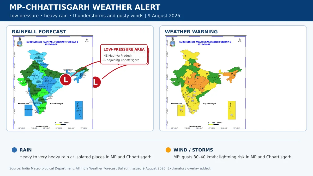
A low-pressure area over northeast Madhya Pradesh and adjoining Chhattisgarh is likely to produce widespread rain and potentially disruptive weather across both states, the India Meteorological Department has said.
According to the IMD’s August 9 bulletin, the associated cyclonic circulation extends up to 7.6 km above mean sea level and tilts southwestwards with height—conditions capable of sustaining intense rain-producing clouds.
The monsoon trough is also passing through Gwalior and the centre of the low-pressure system before extending towards Puri and the east-central Bay of Bengal. These two systems are expected to keep moisture concentrated over central India.
Heavy Rain Warning for MP and Chhattisgarh
Heavy to very heavy rainfall is likely at isolated places across Madhya Pradesh and Chhattisgarh on August 9. Thunderstorms accompanied by lightning are also expected.
In Madhya Pradesh, gusty winds could reach speeds of 30–40 kmph during thunderstorms.
For August 10, the IMD has forecast:
- Heavy to very heavy rain at isolated places in western Madhya Pradesh.
- Heavy rain at isolated places in eastern Madhya Pradesh and Chhattisgarh.
- Thunderstorms and gusty winds of 30–40 kmph in Madhya Pradesh.
- Lightning at isolated places in Chhattisgarh.
Heavy rainfall may continue at isolated places in Madhya Pradesh on August 11, although its intensity and distribution could change as the low-pressure system moves.
Possible Impact
The IMD has warned that intense spells could cause waterlogging in low-lying areas, reduced visibility and temporary disruption to road and rail traffic.
Strong winds and saturated soil may damage tree branches, small trees, standing crops, kutcha houses and other vulnerable structures. Localised flooding is possible where drainage is inadequate.
Residents should avoid sheltering under trees during thunderstorms, stay away from waterlogged roads and follow district-level alerts. Farmers should secure harvested produce and postpone spraying or other field operations during thunderstorms.
Forecast conditions may change, so readers should check the latest district nowcast before travelling.
Low-Pressure Area Brings Heavy Rain Alert for Madhya Pradesh and Chhattisgarh
Digital desk
A low-pressure area over northeast Madhya Pradesh and adjoining Chhattisgarh is likely to produce widespread rain and potentially disruptive weather across both states, the India Meteorological Department has said.
According to the IMD’s August 9 bulletin, the associated cyclonic circulation extends up to 7.6 km above mean sea level and tilts southwestwards with height—conditions capable of sustaining intense rain-producing clouds.
The monsoon trough is also passing through Gwalior and the centre of the low-pressure system before extending towards Puri and the east-central Bay of Bengal. These two systems are expected to keep moisture concentrated over central India.
Heavy Rain Warning for MP and Chhattisgarh
Heavy to very heavy rainfall is likely at isolated places across Madhya Pradesh and Chhattisgarh on August 9. Thunderstorms accompanied by lightning are also expected.
In Madhya Pradesh, gusty winds could reach speeds of 30–40 kmph during thunderstorms.
For August 10, the IMD has forecast:
- Heavy to very heavy rain at isolated places in western Madhya Pradesh.
- Heavy rain at isolated places in eastern Madhya Pradesh and Chhattisgarh.
- Thunderstorms and gusty winds of 30–40 kmph in Madhya Pradesh.
- Lightning at isolated places in Chhattisgarh.
Heavy rainfall may continue at isolated places in Madhya Pradesh on August 11, although its intensity and distribution could change as the low-pressure system moves.
Possible Impact
The IMD has warned that intense spells could cause waterlogging in low-lying areas, reduced visibility and temporary disruption to road and rail traffic.
Strong winds and saturated soil may damage tree branches, small trees, standing crops, kutcha houses and other vulnerable structures. Localised flooding is possible where drainage is inadequate.
Residents should avoid sheltering under trees during thunderstorms, stay away from waterlogged roads and follow district-level alerts. Farmers should secure harvested produce and postpone spraying or other field operations during thunderstorms.
Forecast conditions may change, so readers should check the latest district nowcast before travelling.
Recommended For You
--------
🚨 Beat the News Rush – Join Now!
Get breaking alerts, hot exclusives, and game-changing stories instantly on your phone. No delays, no fluff – just the edge you need. ⚡
Tap to join:
🟢 WhatsApp Channel: Dainik Jagran MP CG
Crave more?
🅕 Facebook: Dainik Jagran MP CG English
🅧 Twitter (X): Dainik Jagran MP CG
🅘 Instagram: Dainik Jagran MP CG
Share the fire – keep your crew ahead! 🗞️🔥